Transmission Company Victoria (TCV) is undertaking field survey activities across the VNI West draft corridor. This work is important and builds our understanding of environmental considerations such as flora, fauna and the geology of the area.
Studies started in October last year and include non-invasive ground investigations and site walkovers to identify key wildlife habitat and vegetation, as well as geotechnical studies which involve drilling small boreholes to determine ground and soil conditions. These activities have mainly been carried out on public land, with the permission of relevant authorities.
Under the comprehensive Environment Effects Statement (EES) process over the next 18 months, TCV will carry out a range of more detailed technical studies including bushfire, cultural heritage and environmental assessments.
If we need to access private property, we will request consent from landholders. We will respect any biosecurity measures and follow farm rules, documented in a formal land access agreement with the property owner.
Survey activities on public land typically require Works Within the Road Reserve (WWRR) permits from local shire councils. These permits are arranged prior to works commencing. TCV does not anticipate major disruptions to local traffic while field investigations are underway; however, appropriate traffic management resources will be in use at each site.
Information on upcoming field surveys and assessments is available below.
| Municipality | Location | Expected window | Survey type |
|---|---|---|---|
| Gannawarra, Buloke, Loddon and Northern Grampians |
Across length of draft corridor | 30 September – 31 December 2024 | Ecology Survey |
Types of Field Survey Works
Land use and planning surveys will help to inform TCV’s assessments of the potential impact on land use and development associated with the construction, operation and decommissioning of the project and identify management measures necessary to address these impacts.
These in-vehicle surveys require crews to utilise public roads driving near to, and crossing the path of, the proposed VNI West transmission line alignment.
Those undertaking these survey activities may also meet with local councils to understand key land use and planning considerations across each local government area.
Assessing land use and planning typically requires a desktop assessment, which review planning and land use issues within an area, supported by site inspections and consultations.
Landscape and visual amenity surveys are taking place across the VNI West draft corridor, allowing TCV to assess, avoid and minimise potential adverse effects for the community regarding landscape and visual amenity.
Field surveys provide greater detail in assessing landscape typology and character assessment, to map and identify landscape character types, and prominent features.
During this survey period, contractors will take photos of landscape views from various public view locations to inform the preparation of photomontage images as part of the landscape and visual impact assessment for VNI West. Each photo location will be recorded by a licensed surveyor.
Specialists conducting these field surveys will spend approximately 15 minutes at each location, setting up, taking photos and surveying the landscape.
Historical heritage site inspections are taking place across the VNI West draft corridor and will inform the historical heritage impact assessment as part of the Environment Effects Statement (EES) process. Historical heritage surveys assess known and potential historical heritage and archaeological sites.
This survey will include a review of the current conditions on site, assessment of previous and potential disturbance to the site, and review whether there is any evidence of historical heritage or archaeological features or deposits present on site. These non-invasive works will be undertaken by qualified and experienced archaeologists and will consist of site walkthrough and photography.
Findings from Historical heritage surveys may include the remains of structural features such as timber footing or artefactual deposits associated with historic buildings or infrastructure throughout the VNI West draft corridor.
TCV will undertake a program of Noise Monitoring field surveys across the VNI West draft corridor.
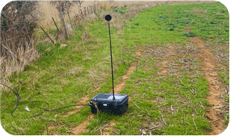
Specialised noise monitors capture numerical data based on noise levels, not live audio recordings, to ensure the privacy of landholders and members of the public.
There are two types of Noise surveys that will be undertaken:
Attended Data Collection Survey – Public Land
These surveys will take place on public land at sites along the roadside, public parks and nature reserves. At each survey location, TCV contracted Noise Specialists will set up the equipment and be in attendance. They will measure the noise levels for between 15 and 30 minutes depending on the location and weather conditions.
Unattended Data Collection Survey – Private Land
These surveys will be undertaken on private land with the consent of the landholder, in accordance with the landholder’s Land Access Agreement. These surveys will require a Noise Monitoring device be left on the premises for between 7 to 14 days. The duration will depend on the weather conditions to ensure a good quality of data is captured.
The landholder will be engaged to assist with identifying the best location for the devices to be set up, which is generally within 10 metres of a residence. The monitors will be secured to a fence post using a chain and lock.
Learn more with TCV’s Noise Surveys fact sheet.
Ecology surveys are used to identify important environmental values, such as wildlife habitats and vegetation. These surveys typically include non-invasive ground investigations, including site walkovers and photography.
These surveys allow TCV to identify flora and fauna within the draft corridor, including threatened plant species and native animals. This information allows the project to predict the likelihood of species occurrence in the region.
Geotechnical field investigations are used to determine the current conditions of soil and rock features in the broader draft corridor region.
TCV is undertaking a program of geological field studies from March to May 2024. These investigations consist of drilling 27 boreholes, each about 100mm in diameter at depths of no more than 35 metres.
All geotechnical drilling-related field work will take place on public land and all required permits have been obtained from relevant local authorities. Crews will be visible on roadsides as investigations take place.
These sites are not indicative of where towers will be located. Once tower sites are determined, further geotechnical bores will need to be undertaken at each of those locations.
Once sites are identified as suitable for geotechnical drilling, engineering, ecological and cultural heritage specialists assess the area for any potential issues before any survey drilling activities begin.
Geotechnical investigations will take place within a fenced off work zone to ensure field investigations can be completed safely. There will be multiple vehicles at each survey site including traffic management, pumping and drilling equipment.
Each borehole is remediated directly after drilling activity concludes. Boreholes are backfilled in strict accordance with the Australian Drilling Industry Association’s guidelines.
Learn more about these surveys in TCV’s Geotechnical Investigations explainer.
High resolution elevation and geographic data is used to inform several key areas of activity for VNI West including route refinement, cultural heritage management plans and environmental impact assessments.
Light detection and ranging (LiDAR) technology is used to gather this data and aerial imagery. The LiDAR process involves a small fixed-wing plane flying between 500m and 1km above the ground, within survey areas of interest along the route of the draft corridor.
More information about the broader program of field surveys for VNI West can be found in the Land Access Technical Survey Activities fact sheet.
Questions about any aspect of VNI West can be directed to TCV via 1800 824 221 or emailed to enquiries@transmissionvictoria.com.au.